Knauss legislative fellowships in Congress help build careers — and they're fun and educational. See our video and fact sheet for details.
If Hurricane Joaquin Comes to the Chesapeake
What kind of storm surge could head up the Chesapeake Bay this weekend if Hurricane Joaquin reaches the Mid-Atlantic?
That depends in part on which forecasting models are right: those which predict the storm will stay out to sea and pass to the east side of the Bay or those which predict it will pass along the west side.
With its counter-clockwise rotation, a hurricane along the east side or ocean side tends to blow water down the Bay. A west-side storm will have the opposite effect: its counter-clockwise winds come out of the south and west, pushing a surge of water up the mainstem of the Bay. That's what happened in 2003 when Hurricane Isabel flooded Annapolis and Baltimore and the low-lying regions of the Eastern Shore.
Oceanographers who study the physics of storm surges worry about the timing of certain natural forces -- some of which you've probably never heard about.
Storm Surge + Tide
One of those forces, of course, is the tide. You've often heard that high tides can increase a storm surges, and in that case you realize that the Bay region was probably lucky Joaquin didn’t arrive last weekend. A storm surge will be amplified if it's rolling up the Bay just when a strong, full moon high tide is underway. And last weekend, as you may remember, brought a “Super Moon” event. The moon was at the perigee or the low point of its orbit, bringing it closer to the earth and amping up its gravitation pull on the tides. That super moon, if you saw it, looked 14% larger than normal.
Now think of the tide as "a long wave" that crosses the ocean. That's the way scientists often talk about the tide, especially those who are physical oceanographers like Bill Boicourt of the University of Maryland Center for Environmental Science. Out on the open ocean the crest of each tidal wave may be only two feet high, says Boicourt, but that wave is a huge bulge of water, a bulge heavy enough to deform the sea floor as it moves across it. The crest moves at high speeds in the deep ocean, and as it moves, the sea floor, elastic as a waterbed you just left, rebounds behind it.
What happens when that tidal bulge enters the mouth of the Chesapeake Bay? This long, heavy wave feels the Bay bottom, says Boicourt, and the friction from that shallow bottom slows it down. The bulge moves more slowly now. Sliding north at about 15 knots an hour, the bulge will take 11 or 12 hours to move from Norfolk at the mouth of the Bay to Havre de Grace at the head of the Bay.
Storm Surge + Slosh
There's a second force, another kind of bulge, that could build a big storm surge from Hurricane Joaquin. This bulge bounces up and down the Bay, but has been little studied in estuaries. Scientists call it a seiche, but Boicourt likes to call it a sloshing. Remember how water sloshes back and forth in your bathtub? In the Bay, when a bulge of water is pushed down the Bay or up the Bay, there will be a rebound of sorts.
The slosh, for example, could start with a Nor'easter blowing water down the Bay -- and, yes, we now have a Nor'easter hitting the region as we wait for the arrival of Joaquin. Winds from the north create a south-moving bulge that flows down past the mouth of the Bay and out to the ocean.
So how does that south-moving bulge create a rebound? As the bulge moves south towards the ocean, it creates a slope in the water surface along the Bay. The low point in the slope would be up north near Havre de Grace or Baltimore, the midpoint of the slope would be south near Norfolk, and the high point, at least in theory, would be out in the ocean.
Water tends to run downhill, both in theory and in fact, so once the wind stops blowing from the north, the water from that high point out in the ocean will slosh downhill back through the Bay, rolling past Norfolk, headed north towards Baltimore and on to the top of the Bay. The natural oscillation period for this back-and-forth swing is two days. There’s a famous formula behind this estimate.
You see the dilemma: What if that rebound from a south-moving bulge is happening just when Joaquin is pushing a storm surge north? Scientists call that an example of "resonance." The effect of the storm and the effect of the slosh will both be magnified. "You are going to get a very efficient transfer of energy," says Boicourt. "And you are going to flood Baltimore."
Storm Surge + Low Pressure
Let's add another rarely seen force you've probably never heard about. What if the low-pressure center of Joaquin is moving up the Bay right on top of the storm surge? That would be an example of a rare, even less-studied phenomenon called a Proudman resonance. “If you have low pressure in the atmosphere, that means less air on top of the water," says Boicourt. Less pressure lets a wave grow taller. A low pressure zone moving in sync with a wave is a rare event, named for the scientist who first identified it, but Boicourt now thinks a Proudman resonance might have been at work when Isabel sent a huge storm tide that flooded downtown Baltimore.
Storm Surge + the Big Squeeze
Here's another player: the big squeeze. As a bulge of water moves north, the Bay narrows, creating a funnel that squeezes water into taller bulges. The result is a faster-moving bulge. Remember friction, the bottom force that slows a wave down? As a bulge grows taller, friction becomes a smaller part of the total bulge, a weaker force. Taller bulges move faster than shorter bulges. And they carry more water.
So what kind of storm surge will Joaquin send up the Bay? Oceanographers are trying to measure and estimate and predict the effect of each of those forces. If you want to figure that out for yourself, check the weather maps first to see whether Joaquin moves along the east side or the west side of the Bay. If it's a west side storm, they try adding up these forces: storm surge + tidal wave + the big slosh + the Proudman resonance + the big squeeze. Good luck with that.
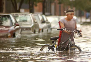
Photo, top: A Baltimore street during Hurricane Isabel, credit, Max Franz
See all posts from the On the Bay blog
Program Announcements
News and Blogs


ON THE BAY - BLOG ARCHIVE
ON THE BAY - BLOG TOPICS
Featured Fellow
Nina Santos
Nina Santos is a Ph.D. student at the Chesapeake Biological Laboratory at the University of Maryland Center for Environmental Science. For her dissertation, she is focused on small shrimp-like crustaceans called mysids – an understudied yet important part of many estuarine and coastal food webs.
Featured Research Project
Developing a habitat model for mysids, an important link in Chesapeake Bay food webs
Mysids are important mesozooplankton prey for many species of fish in Chesapeake Bay and are an important link in transferring energy from lower to upper trophic levels. Mysids also serve as biological vectors for benthic-pelagic coupling due to their diel vertical migration and omnivorous prey-switching behavior, which makes mysids important regulators of food web architecture. Despite their central role in coastal food webs, surprisingly little is known about mysid ecology and dynamics in Chesapeake Bay.
