Knauss legislative fellowships in Congress help build careers — and they're fun and educational. See our video and fact sheet for details.
Landscaping and Modeling Can't Save the Bay, but They Can Help It Along

Scientists have long used physical models that simplify the complexities of real environmental systems in order to make informed predictions of future change.
One of the first such models was the Mississippi River Basin Model built between 1943 and 1966. This 200-acre replica of the actual Mississippi River watershed located in Clinton, Mississippi was operated for decades to better understand how to manage flood risk. The Chesapeake Bay had such a model, too, in Matapeake, used to understand how best management practices reduce the flow of pollution, and by how much. (See our story in Chesapeake Quarterly). Now, some landscape architects are experimenting with similar approaches to design more sustainable, resilient, aesthetic landscapes.
Situated in downtown D.C., surrounded by concrete and asphalt, the American Society of Landscape Architects hosted a talk by Bradley Cantrell about ecological design using new methods of computational simulation. Cantrell is the Professor and Chair of Landscape Architecture at the University of Virginia School of Architecture.
The Chesapeake Bay can be viewed as a shared landscape that serves many different purposes: recreation, a habitat for sustainable aquaculture, tourism, and a home for many people. Landscape architects combine ideas from environmental science, design, urban planning, and human culture to create places that function as recreation space while also better managing limited resources, protecting the landscape's “wildness”, and preserving its beauty for future generations.
 |
|
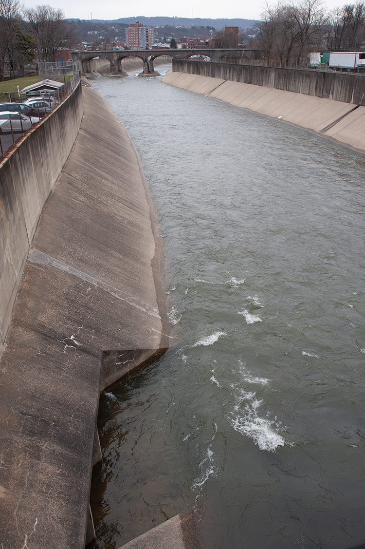
Engineers, architects and city planners focused on flood control, so they often buried waterways and pushed the water away. New landscape-modeling tools are moving away from solutions like this one, where a concrete channelized flood-control structure runs through the heart of Cumberland, Maryland. Photo credit: Nicole Lehming |
We can improve Chesapeake Bay management by thinking about it through the lens of landscape architecture, Cantrell says.
The difference between what Cantrell does and the approach of traditional landscape architects is that he uses new technologies to visualize and relate to landscapes. “We do this with models, simulations, and animations, built from data that give us a deeper understanding of how landscapes work,” he said.
How does he do this? During the talk in Washington, Cantrell illustrated the movement of sediment in water through a model of the Morganza Spillway — a series of gates that diverts water from the Mississippi River into the Atchafalaya Basin by opening during flood events. Inspired in part from the large-scale Mississippi River Basin Model Cantrell described earlier, he and his students built their model watershed with some plywood, foam, a water source, sediment, computer-controlled plexiglass gates, and a series of advanced cameras. Cantrell showed how opening and closing certain gates for different amounts of time could dramatically alter the downstream landscape, with rising and falling sand landforms. It resembled a sophisticated school science project, if anyone at your school has computer-controlled gates and small advanced cameras.
Cantrell is quick to say that this model, which fits into a laboratory room, is merely a representation of real life. But it is often these representations that are used to engineer structures and maintenance regimes to control the environment.
“We are making decisions out of the artificial reality … [and] using it as a way to interact with the physical world,” said Cantrell. These models and simulations, Cantrell argued, also “bring out features of the physical world beyond the human senses,” and we can “use technology to uncover” how things used to behave, before major modifications, said Cantrell. With the miniature Morganza Spillway in action, Cantrell showed how the depth of the water changed over time at a cross section downriver. Such changes would not have been obvious if one was watching, because they change so slowly.
On another project Cantrell was involved with, this one focusing on a section of the Los Angeles River running through the city known as the “bow tie”, his computational and technology-focused methods of landscape architecture helped create a dialogue between civil engineers, city planners, and environmental scientists to find the best course for the river through the city. In this case, better results were realized with a more diverse group of experts at the decision table.
As with the Los Angeles River, landscape architects could add value to Chesapeake Bay management discussions using Cantrell’s technology-focused approach to landscape architecture.
Photo, top: The U.S. Army Corps of Engineers once kept a physical model of the system at Matapeake. It was shuttered in 1984. Photograph, U.S. Army Corps of Engineers
See all posts from the On the Bay blog
Program Announcements
News and Blogs


ON THE BAY - BLOG ARCHIVE
ON THE BAY - BLOG TOPICS
Featured Fellow
Nina Santos
Nina Santos is a Ph.D. student at the Chesapeake Biological Laboratory at the University of Maryland Center for Environmental Science. For her dissertation, she is focused on small shrimp-like crustaceans called mysids – an understudied yet important part of many estuarine and coastal food webs.
Featured Research Project
Developing a habitat model for mysids, an important link in Chesapeake Bay food webs
Mysids are important mesozooplankton prey for many species of fish in Chesapeake Bay and are an important link in transferring energy from lower to upper trophic levels. Mysids also serve as biological vectors for benthic-pelagic coupling due to their diel vertical migration and omnivorous prey-switching behavior, which makes mysids important regulators of food web architecture. Despite their central role in coastal food webs, surprisingly little is known about mysid ecology and dynamics in Chesapeake Bay.
Related Products

Chesapeake Environmentalism: Rethinking Culture to Strengthen Restoration and Resource Management
In the first issue of this monograph series, Chesapeake Perspectives, cultural anthropologist Dr. Michael Paolisso provides his perspectives on environmentalism and the Chesapeake. Building on his studies of diverse communities—from watermen to…
