Knauss legislative fellowships in Congress help build careers — and they're fun and educational. See our video and fact sheet for details.
Working in the Bay: Everyone's Got His Niche
It’s 9 am. The tide is just beginning to ebb. Greg Silsbe and I are loading up the small motor boat at the Horn Point Laboratory’s boat landing. Working quickly to avoid becoming stranded in the shallow basin with the outgoing tide, we transfer our gear from the back of Greg’s car to the bow of the boat. Greg parks his car while I undo the dock lines.
I run through a mental checklist before we set off: data logger, power supply, floating rig, two light sensors, sample bottles, cooler, GPS, toolbox, sunscreen, and drinking water. We are all set to go. Greg starts the engine and begins piloting us out into the Choptank River on Maryland’s Eastern Shore.
Greg is my mentor in the Research Experiences for Undergraduates program, sponsored by Maryland Sea Grant. The project supports undergraduates to conduct research for a summer on the Chesapeake Bay. Before this fellowship, I had only a vague notion of what constituted marine research. I had seen glossy photos of scientists lowering interesting-looking objects into the water, but I never understood the purpose of the expensive-looking tools. Now, after my second month of working with Greg, I have gained a finer appreciation of the role technology plays in marine science research.
Greg is a scientist who wears many hats. His chief specialty is the physiology of phytoplankton (the microscopic plants of the ocean), though for the purposes of our project, Greg is using the tools of remote sensing. It’s a method that characterizes the amount and nature of organic and inorganic particles in water through precise measurements of color. Greg and I are out on the water to collect light data that we will use to determine water quality in the Choptank.
Scientists have historically used other methods to study water quality in the Chesapeake, including lab measurements of water samples. Using remote sensing, we can in principle measure water quality over a large portion of the Bay more quickly and cost effectively.
.jpg) |
|
Hyperspectral radiometers in float. One sensor is pointed downwards to collect upwelling light; the other is pointed upwards to collect downwelling light. Credit: Max Spehlmann |
But coastal and estuarine environments are notoriously difficult to study using remote sensors: a high amount of suspended sediments make it difficult to derive meaningful information from light data. Fortunately, new techniques take advantage of extremely sensitive light detectors, known as hyperspectral radiometers, to more accurately gauge concentrations of water constituents such as chlorophyll-a (the pigment that makes phytoplankton and plants green) and sediment. Special algorithms identify the unique light spectra they emit.
On today’s boat trip, Greg and I are gathering data to test the accuracy of the new algorithms by comparing lab-measured water samples containing chlorophyll-a with chlorophyll-a estimated from our radiometers.
As opposed to remote sensors on satellites, our radiometers are useful only for measuring very small areas, like parts of the Choptank River. In the future, NASA is launching the PACE satellite which will utilize hyperspectral sensors to scan entire oceans and coastlines. But before these data can be used to monitor coastal waters, accurate algorithms will need to be derived and tested. Greg and I are working on that today.
Drone video of our research trip on the Choptank River. I am wearing a red shirt and my mentor, Greg Silsbe, is wearing a dark shirt. The video shows us following the typical procedure for deploying the radiometric float and collecting water samples at each site. The final panorama simulates how different elements in the water affect the reflected light spectrum, e.g., chlorophyll contributes green light to the light received by the video camera. Video by Max Spehlmann, music courtesy of Dlay.
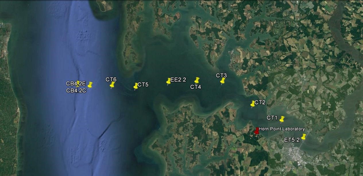
This will be the fourth time we’ve sampled the river, and by now, we’ve developed a routine. We begin by cruising out to our first sampling site in the center of the Chesapeake. Then we make our way upriver stopping nine more times to collect data. Ideally we would be collecting our samples under constant conditions. However, conditions out on the water are always changing. Last week the sky was hazy, the water especially green. Today, the Choptank is decidedly choppy, and what normally takes us 45 minutes has turned into a rocky hour-long commute.
 |
|
Stations used for the transect throughout the summer of 2016. Credit: Photo generated using Google Earth |
I kneel in the front of the boat, attaching the light sensors to the yellow float, a formidable task while underway. After a couple of attempts, I manage to align the sensors with the metal casters, and screw them on tight. I stand up, and move behind the windscreen. Greg lets me drive as he struggles to take a couple of swigs of coffee.
After driving for ten minutes, Greg reminds me that we are entering the “minefield.” There are probably 50 little red buoys strewn across our path. I slow down the boat and redouble my attention. The buoys mark cages set out by watermen, people who work to make a living from the Bay. Their long, flat boats are ubiquitous; they trudge up and down the river, managing their crab cages and, at other times of the year, hauling in fish nets and dredging for oysters. The Bay isn’t nearly as productive as it once was, and now the estuary is able to support the livelihood of only a small fraction of the watermen it supported 20 years ago.
The work of a scientist and the work of a waterman may seem completely different. But, we are all on the same side. If Greg and I are doing our jobs right, the water quality data we pull from the Bay today will be used to guide restoration decision-making in the Chesapeake. With proper management, and sufficient time, stocks of fish and crab will be replenished and the economy of the Bay will improve. I throttle the boat back up to speed as the last buoy slips by. We are now 20 minutes away from our westernmost station. Field work is one of my favorite things about doing science, and today, even with the waves, I’m glad to be out on the river.
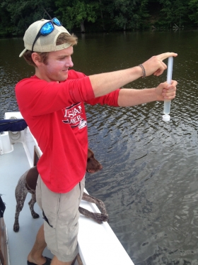
Photo, top left: The author sampling for chlorophyll concentration in the upper Choptank River. Credit: Matthew Pluta
Learn more about Maryland Sea Grant's Research Experiences for Undergraduates program, including how to apply.
Sign up to receive email alerts about new posts to the Fellowship Experiences blog
See all posts to the Fellowship Experiences blog

Chesapeake Quarterly Magazine
A Growing Industry: Advancing Oyster Aquaculture in Maryland